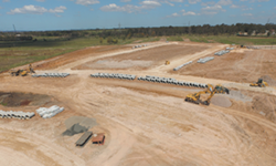
Carving out residential construction sites
 Western Earthmoving is a civil contractor who builds roads, subdivisions, services, and drainage with most of their work being residential and in Western Sydney and Wollongong.
Even though Western Earthmoving was utilising a number of advanced site-positioning technologies, the company’s field managers couldn’t quickly determine current elevations on the job site. Rather, they had to rely on surveyors to provide the information.
In order to equip its field managers with the same digital information, 3D constructible models, and GNSS positioning used by its surveyors; Western Earthmoving adopted the Trimble SitePulse system.
Within three months the workflow of their field managers was transformed, with the change impacting the wider team also. Trimble SitePulse allowed the company’s field managers to see all the information they need onscreen, for example, the linework of a road, the centerline, and lot boundaries. A 3D model of the finished surface level instantly showed how much cut or fill needed to happen onsite. “The system lets anyone easily picture where they are on a job,’ says the Western Earthmoving project surveyor. “And it gives basic information only so non-techy people can see clearly because it’s very simple.”